Volunteering was something else I wanted to get a better idea of while I was up there. Family responsibilities meant that it wasn't possible to volunteer over golden week, but also media had such conflicting reports about aid and volunteers - too many volunteers, not enough volunteers, too much inappropriate aid, totally inadequate aid, petrol supplies and roads restored, petrol supplies and roads not restored. What to make of it?
I suspect it's all true. It's a huge area and because something is true in one place, doesn't necessarily mean it is true in another, and vice versa.
I think some general principles hold true for the whole area.
- to be useful there you would probably need to have the following
a) own transport,
b) own supplies - inc water, food, boots, gloves, clothes - it can be cold and wet. It is not possible to rely on shops being by the coast.
c) a clear purpose for being there - being somewhere where there is enough organisation to be able to tell people what needs to be done.
d) a positive compassionate spirit
Volunteers that can do all of the above I am sure are sorely needed in most parts of affected areas.
One also would need to be mindful of
a) potential for lack of hygiene,
b) not creating extra rubbish there - PET bottles, food wrappers, hygiene supplies.
c) I'd recommend menstruating women who wanted to go, consider investing in a mooncup http://www.mooncup.co.uk/ over traditional sanitary options, from a hygiene point of view and from a rubbish disposal point of view.
d) being empathetic - speaking for myself, I can't fathom the depth of trauma, expecting people to talk about their suffering, taking photos conspicuously, can create more trauma. Finding the right balance between sensitivity and being a cheering/ positive/ motivating presence I imagine isn't easy.
Wednesday, 11 May 2011

Yamada-Otsuchi-Kamaishi
 |
It's still a beautiful coast - we stopped for a break just south of Yamada |
 |
Otsuchi - the mayor of Otsuchi was among about 2,000 of the 17,000 people of Otsuchi who are dead or missing. |
 |
I don't have words to describe the destruction here. These are temporarily constructed barriers at the side of the road. |
 |
A drug store |
 |
Otsuchi |
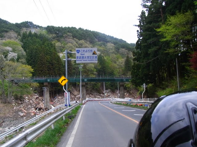 |
This picture in part answered one of my questions. Along the coastline, almost without exception the 'tsunami inundation zone' signs were pretty accurate indicators of the areas that were affected by tsunami. When I was up here in before, I was surprised by how far away from the coast the signs were. I was also surprised that the towns were mostly in these areas. I concluded the evacuation plans were very good. This sign marks almost exactly the extent to which the tsunami reached. On the other side of Otsuchi, just north of this sign, however, the tsunami inundation zone sign was at a guess 500 before the end of the tsunami affected area. The inaccuracy of that sign seemed to be an aberration. That's no consolation for the people who there who may have assumed they were beyond the reach of tsunami. See the next posting about Ishinomaki's Okawa primary school. |
 |
The space between the coast and the hills is so narrow in places. |

 |
Piles and piles and piles of rubbish..... |
 |
Jietai, what a tough job. They have been doing a remarkable job. They are underpaid, under appreciated, and at the moment absolutely stretched beyond the extent of their capacity. We saw them working in Kamaishi, this is at a michi no eki in Tono, inland in Iwate. They have been doing an exceptional job. |
Reposted from http://ponkanchan.blogspot.com/2011/05/yamada-otsuchi-kamaishi.html
Miyako to Yamada
Going south from Jodogama. The pictures below are in Miyako and Yamada.
 |
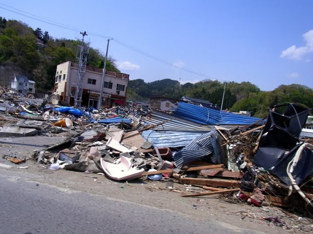
A ship still there, but a lot of debris cleaned, the roads have been totally cleared. |
 |
Piles of rubbish, but very neatly cleaned. |
 |
A couple of km down the road |
 |
The houses are all marked with paint to say they have been checked - either by the Japanese Self Defence Force or the US military. |
 |
| Driving along, there was no way to know the fate of occupants of any of the buildings. |
 |
road barriers bent |
 |
destruction... had the houses been built up the hill..... |
 |
the sea walls did not protect, though looking at the towns it is possible that they may have reduced damage - I haven't read anything about it yet. It was one of my unanswered questions. |
 |
With the sea walls, some tsunami gates were broken, I am not sure to what extent they served as a hindrance by trapping flood water inside the villages. |
 |
Nothing left... |
 |
there has been a fantastic effort made with the roads. The road has been rerouted ahead here. |
 |
A chilling aspect was the total lack of people in much of the area. I had an idea people would be out cleaning up... there was no excess of volunteers anywhere - there were no volunteers anywhere that we saw. I don't mean all people were dead, they aren't, though many are, many also survived. It would be an utterly heartbreaking sight for any survivor. |
Reposted from http://ponkanchan.blogspot.com/2011/05/miyako-to-yamada.html
Miyako and Jodogahama
We stopped to buy petrol at what was probably the northern edge of Miyako's local govt area. The petrol station was right on the coast but very high up and quite ok. There was a junior high school opposite that was also quite ok, and there were kids outside playing tennis despite the stiff wind.
Jodogahama was one of the highlights of our trip in 2006. I really wanted to go back and see it again, particularly after the earthquake. Driving along this time, it seemed that the cliff areas were ok, debris, but that will clear in time, with Jodogahama though, I wondered whether there would be anything much of the sand left. This is a youtube clip of the destruction on Jodogahama - the voice is in Japanese, but the pictures give enough of a sense of it.
The clean up effort has been phenomenal.

reposted from ponkanchan.blogspot.com
 |
| Looking to the coast from the petrol station - concrete blocks are broken, but otherwise the beach has been cleared. I am not sure what the the story of the boats is, but they would not have been there like that after the tsunami |
 |
| The bridge across - taken from the petrol station |
 |
| Jodogahama 2006 |
 |
| Jodogahama 2006 |
The clean up effort has been phenomenal.
 |
| Jodogahama May 2011 |
 |
| May 2011 |
 |
| The restaurant on the beach front has been washed out and is now boarded up. |
 |
| When I was up there I thought the water had receded massively, it has somewhat, but that impression is exacerbated by the loss of vegetation. |

 |
| The road way has been washed out |
 |
| The concrete paths remain in great condition, though the foundations have been washed out. |
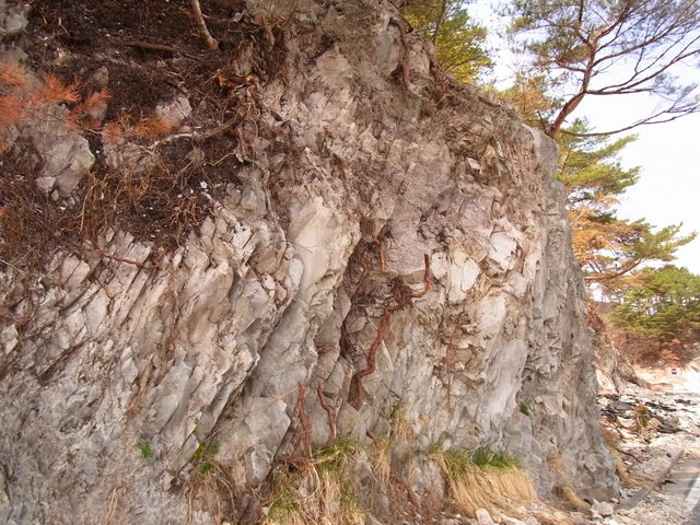 |
| The rocks are still beautiful. |
 |
| Looking at this, I feel very hopeful that the tourist industry will be able to reconstruct. |
Sanriku impressions
I have four overwhelming impressions of the tsunami afffected areas
1) the scale. Unbelievable. Almost impossible to fathom. Almost every single inlet / flat piece of land has been affected in the area we passed through. (Kuji - Kamaishi).
2) the effort being made. The whole of highway 45 from Kuji -Kamaishi is trafficable. Roads have obviously been prioritized, but it's
3) the fine line between destruction and survival.
4) The almost complete lack of people.
1) the scale. Unbelievable. Almost impossible to fathom. Almost every single inlet / flat piece of land has been affected in the area we passed through. (Kuji - Kamaishi).
2) the effort being made. The whole of highway 45 from Kuji -Kamaishi is trafficable. Roads have obviously been prioritized, but it's
3) the fine line between destruction and survival.
4) The almost complete lack of people.
Places in the north - Hachinohe and Kuji were affected, Kuji more so, though not Kuji town proper. In both places though it appears that the ratio of damaged area to non damaged area is quite low, which would explain why these areas have had the resources and capacity to clean up. Key infrastructure was not really rendered unusable. In Kuji there were large piles of rubbish on highway 45 - back a bit from the coast - but it seemed very orderly. The local govt, central govt, American military and the Japanese Self Defence Force, as well as local residents are likely responsible.
In one of the villages of Kuji near the coast they were having a local clean up day - people - mostly elderly up and about weeding common lands, sweeping etc. I figured if they were worried about pulling out weeds, other destruction was not needing to be attended to, despite it being so close to the coast.
I should have had a note book out and been more systematic in recording pictures against place names. Even going along though, I wasn't always sure where we were. Signs on local roads is not a strong point in Japan..
Had I done so, it would have been a more useful record.....
Had I done so, it would have been a more useful record.....
 |
| A bridge just south of Kuji next to the coast - the barriers at the sides have been installed temporarily. It is either on Hwy 45 or just off it. |
 |
| Presumably debris has been cleaned up here somewhat. |
 |
| This is the same location with a wider view - some debris, but very little the area had no homes that were washed out as far as I could see. |
 |
| Looking south from the same spot |
 |
| Traffic was diverted onto a track that went alongside the river. This would have been untrafficable after the tsunami |
 |
| 30 km or so further south - probably still in Kuji |
 |
| The Shimohei area between Kuji and Miyako - Tanohata? perhaps. Everything in the foreground has gone, houses remain at the back. |
 |
| The Kita Rias trainline has been totally destroyed in place. There has been talk of replacing it with buses. Piles of debris |
 |
| Passing by it's not possible to know what used to be in many places. |
Monday, 9 May 2011
The Sanriku
Several years ago my husband & I took a motorbiking trip up the Sanriku coast. Although the larger towns seemed to blend into a certain sameness, I was so charmed by the area. Little villages with people out mending fishing nets, pristine beaches, rivers that ran with no concrete lining the banks, a kokumin shukusha with an feast of freshly caught fish, tiny settlements dotted around isolated peninsula. Posters of Ichiro Ozawa all over the place that had me thinking with such good roads being built it's no wonder that he keeps getting re-elected...
I have been wondering a lot about how things are going there, wondering whether the places we stayed at, the sights we saw, the people we encountered survived.. There has been a lot in the news about Kesenuma and other places in Miyagi. I've seen stories on places as far north as Miyako, but nothing beyond... Rather than following the kosoku straight down from Hachinohe to Ashiro I wanted to take the coast road as far as Kuji or Miyako if possible to get some sense of the situation in places I hadn't been hearing about.
There were specific things I wanted to know.
- what was the situation between Hachinohe & Kuji & Miyako?
- how did Jodogahama fare?
-did the tsunami inundation zones signs accurately predict the areas that were flooded?
- how did the concrete barriers / tsunami walls stand up, did they offer any protection? did they smaller ones scatter?
- are the roads trafficable?
- how much clean up has been done?
- what could a person do to help there?
I took some photos, but basically decided not to stop to take photos. Partly the practicality of travelling more than 800km back to Tokyo in a day on a motorbike meant stopping was impractical. Also in part even though I was going with specific things I wanted to know, I felt like stopping to take photos while doing nothing to help was akin to being a ghoulish voyeur of misery and death.
I didn't get answers to most of my questions, but I did get some. Will post with some pictures when blogger is doing pictures again.
I have been wondering a lot about how things are going there, wondering whether the places we stayed at, the sights we saw, the people we encountered survived.. There has been a lot in the news about Kesenuma and other places in Miyagi. I've seen stories on places as far north as Miyako, but nothing beyond... Rather than following the kosoku straight down from Hachinohe to Ashiro I wanted to take the coast road as far as Kuji or Miyako if possible to get some sense of the situation in places I hadn't been hearing about.
There were specific things I wanted to know.
- what was the situation between Hachinohe & Kuji & Miyako?
- how did Jodogahama fare?
-did the tsunami inundation zones signs accurately predict the areas that were flooded?
- how did the concrete barriers / tsunami walls stand up, did they offer any protection? did they smaller ones scatter?
- are the roads trafficable?
- how much clean up has been done?
- what could a person do to help there?
I took some photos, but basically decided not to stop to take photos. Partly the practicality of travelling more than 800km back to Tokyo in a day on a motorbike meant stopping was impractical. Also in part even though I was going with specific things I wanted to know, I felt like stopping to take photos while doing nothing to help was akin to being a ghoulish voyeur of misery and death.
I didn't get answers to most of my questions, but I did get some. Will post with some pictures when blogger is doing pictures again.
Hachinohe
A family wedding took me to Hachinohe on the Pacific side of Aomori in the far north of Honshu this golden week. We came up through Niigata and Akita and just spent a few hours there before the 5pm wedding. My cousin in law and his wife had sent out their wedding invitations the weekend before the earthquake. With the tsunami affecting the port areas of the city, and with both of them working at a local hospital, they felt torn about whether it was better to postpone the wedding till things had stabilized. And yet earthquakes and tsunami underscore the impermanence of life... and they opted to proceed with it, and were glad they did. So was the hotel...
I hadn't been to Hachinohe before but was impressed with upbeat feel to the city. Unlike much of Tohoku, particularly places in the shadow of the shinkansen lines, buildings looked fresh and well maintained, and there didn't seem to be the cancerous Aeon-ization that has rotted the core of regional cities.
Four people were killed in Hachinohe after the earthquake and the phone and electricity blackout lasted for several days. Aomori has has dropped off the radar in reporting in favour of places further south where much greater damage was sustained. There is still some evidence of damage sustained.
 |
| Trees along the foreshore. Shell petrol station in the background was operating again. |
 |
| Debris along the foreshore - very orderly, and had presumably been tidied up, but it was clearly not meant to be there. |
 |
| We ate onigiri for lunch here - the seat was still fine - just in need of replanting |

 |
| A rusted out boat washed up onto the foreshore being disassembled |
 |
| The parking lot at Kabushima - a nesting ground for seagulls |
 |
| From Kabushima looking north |
 |
| The seagulls seem to have survived ok |
 |
| From Kabushima looking north |
 |
| The toilet block |
Subscribe to:
Posts (Atom)